PONTCYSYLLTE SOUTHERN APPROACH EMBANKMENT
The People's Collection is using (with some modifications) the licence developed by the Creative Archive Licence Group, including the BBC, the British Film Institute (BFI). Channel 4, the Open University, Teachers TV, Museum and Library Archive (MLA) and ITN Source.
Read more about the All Rights Reserved.
Description
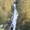
RCAHMW digital photographic survey of Pontcysyllte Southern Approach Embankment, Llangollen Canal, by Iain Wright, 14/3/2007.
External source:
Date Joined:
24/07/2009
Owner:
Investigators' Digital Photography
License information:
Reproduced by permission of
Royal Commission on the Ancient and Historical Monuments of Wales
Copyright Details:
Crown Copyright: Royal Commission on the Ancient and Historical Monuments of Wales 2007
Publisher Ref:
31941
Item uploaded:
17/11/2009
Date originally created:
16/3/2007
Views:
583
Favourites:
1
More items with these tags
Related items
-
Porthmadog History
Type ItemUploaded by LleCHI LleNI -
Porthmadog history [timeline 1600-2021]
Type ItemUploaded by LleCHI LleNI -
Map of Tenby and Penally Pembrokeshire 1866
Type ItemUploaded by Penally History Group -
Ordnance Survey map of Ritec embankment Penally Pembrokeshire
Type ItemUploaded by Penally History Group -
1in Ordnance Survey map of Penally Pembrokeshire
Type ItemUploaded by Penally History Group -
1in Ordnance Survey map of Penally Pembrokeshire
Type ItemUploaded by Penally History Group -
1in Ordnance Survey map of Penally Pembrokeshire
Type ItemUploaded by Penally History Group -
The History of the Reclamation Penally Pembrokeshire
Type ItemUploaded by Penally History Group -
Embankments Penally Pembrokeshire
Type ItemUploaded by Penally History Group -
The Coast and the Ritec River Penally Pembrokeshire
Type ItemUploaded by Penally History Group
Contact Us
To request take down or report racist, offensive or otherwise harmful content.
You must be logged in to leave a comment