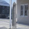
Mason-Dixon boundary marker
Description
The Mason-Dixon Line (or Mason and Dixon Line) was surveyed between 1763 and 1767 by Charles Mason and Jeremiah Dixon in the resolution of a border dispute between British colonies in Colonial America. It forms a demarcation line among four U.S. states, forming part of the borders of Pennsylvania, Maryland, Delaware, and West Virginia (then part of Virginia).
In popular usage, especially since the Missouri Compromise of 1820 (apparently the first official use of the term "Mason's and Dixon's Line"), the Mason-Dixon Line symbolizes a cultural boundary between the Northeastern United States and the Southern United States (Dixie).
The Mason-Dixon line is most commonly associated with the division between the northern and southern (free and slave, respectively) states during the 1800s and American Civil War-era.

More items with these tags
This item also appears in

Contact Us
To request take down or report racist, offensive or otherwise harmful content.

You must be logged in to leave a comment