Ynyslas Rocket Firing Test Track, May 1946
Description
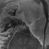
Aerial photographs in the Royal Commission's collection can help to piece together clues about the facilities that were build for the rocket scientists. This image shows two of the main rocket test tracks. One running west to east and ending in the present day beach carpark. The other running east to west from what is now the Sea Rivers Caravan Park to end in an amphitheatre excavated into the sand dune. Some of the small buildings associated with taking observations can still be seen near both tracks.

More items with these tags
This item also appears in


Contact Us
To request take down or report racist, offensive or otherwise harmful content.

You must be logged in to leave a comment