Prickeston Farm Map 3 House extract
Description
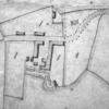
An estate map of Prickeston - given to the tenant. This map was produce in the early nineteenth century, possibly late eighteenth century. The extract shows the arrangements of the farm buildings at this time. Apologies for no scale. This info to follow. North is approximately to the top of the plan.
Compare to the current "satellite" view of the area.

More items with these tags
This item also appears in

Contact Us
To request take down or report racist, offensive or otherwise harmful content.

You must be logged in to leave a comment